
Mapa topográfico Boston
Mapa interactivo
Haga clic en el mapa para ver la altitud.
Acerca de este mapa
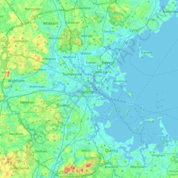
Nombre: Mapa topográfico Boston, altitud, relieve.
Lugar: Boston, Suffolk County, Massachusetts, 02102, United States (42.20025 -71.21829 42.52025 -70.89829)
Altitud media: 26 m
Altitud mínima: -5 m
Altitud máxima: 189 m
Boston has an area of 89.63 square miles (232.1 km2)—48.4 square miles (125.4 km2) (54%) of land and 41.2 square miles (106.7 km2) (46%) of water. The city's official elevation, as measured at Logan International Airport, is 19 ft (5.8 m) above sea level. The highest point in Boston is Bellevue Hill at 330 feet (100 m) above sea level, and the lowest point is at sea level. Boston is situated on Boston Harbor, an arm of Massachusetts Bay, itself an arm of the Atlantic Ocean.