
Gracias por apoyar a este sitio ❤️
Haz una donación
Haz una donación
Mapa topográfico Fürstenfeld
Haga clic en el mapa para ver la altitud.
Gracias por apoyar a este sitio ❤️
Haz una donación
Haz una donación
Fürstenfeld
Fürstenfeld is located in the lower Freistritz valley near the Burgenland border. Elevation of the urban area ranges from 255m to approximately 300 m ü. A. The city`s central part sits on a river terrace two dozen meters above the valley floor.
Gracias por apoyar a este sitio ❤️
Haz una donación
Haz una donación
Acerca de este mapa
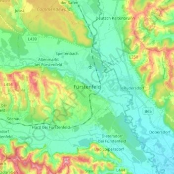
Nombre: Mapa topográfico Fürstenfeld, altitud, relieve.
Altitud media: 283 m
Altitud mínima: 232 m
Altitud máxima: 406 m
Gracias por apoyar a este sitio ❤️
Haz una donación
Haz una donación