
Gracias por apoyar a este sitio ❤️
Haz una donación
Haz una donación
Mapa topográfico Gavdos
Haga clic en el mapa para ver la altitud.
Gracias por apoyar a este sitio ❤️
Haz una donación
Haz una donación
Acerca de este mapa
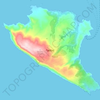
Nombre: Mapa topográfico Gavdos, altitud, relieve.
Altitud media: 56 m
Altitud mínima: -2 m
Altitud máxima: 368 m
Gracias por apoyar a este sitio ❤️
Haz una donación
Haz una donación
Otros mapas topográficos
Haga clic en un mapa para ver su topografía, su altitud y su relieve.
Gracias por apoyar a este sitio ❤️
Haz una donación
Haz una donación
Meskla
Greece > Region of Crete > Chania Regional Unit
Meskla (Μεσκλά) is a village in the municipality of Platanias, a regional unit of Chania, western Crete, in Greece. According to the 2021 census it has 268 inhabitants. It is built on an altitude of 200 meters, at the northern foothills of the White Mountains, in the valley of the river Keritis. It is 21…
Altitud media: 422 m
Gracias por apoyar a este sitio ❤️
Haz una donación
Haz una donación
Gracias por apoyar a este sitio ❤️
Haz una donación
Haz una donación
Gracias por apoyar a este sitio ❤️
Haz una donación
Haz una donación
Gracias por apoyar a este sitio ❤️
Haz una donación
Haz una donación
Gracias por apoyar a este sitio ❤️
Haz una donación
Haz una donación