
Gracias por apoyar a este sitio ❤️
Haz una donación
Haz una donación
Mapa topográfico Oberlottenweiler
Haga clic en el mapa para ver la altitud.
Gracias por apoyar a este sitio ❤️
Haz una donación
Haz una donación
Acerca de este mapa
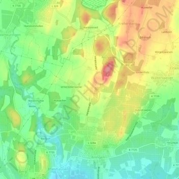
Nombre: Mapa topográfico Oberlottenweiler, altitud, relieve.
Altitud media: 456 m
Altitud mínima: 413 m
Altitud máxima: 512 m
Gracias por apoyar a este sitio ❤️
Haz una donación
Haz una donación
Otros mapas topográficos
Haga clic en un mapa para ver su topografía, su altitud y su relieve.
88048
Deutschland > Baden-Württemberg > Bodenseekreis > Friedrichshafen > Ailingen > Oberlottenweiler
Altitud media: 457 m
Gracias por apoyar a este sitio ❤️
Haz una donación
Haz una donación