
Haz una donación
Mapa topográfico Birgunj
Haga clic en el mapa para ver la altitud.
Haz una donación
Birgunj
Birgunj is located in the Terai plain which is the northern part of the Indo-Gangetic plain. Birgunj metropolitan city has an elongated shape. The variation in altitude is in the range of 78 m to 95 m when moving from south to north of Birgunj. Although the range of altitude variation is small, but there is a high micro-topographical variation. The city lies about 90 m above sea level. Quaternary sediments are mainly found in the area. Soil is very fertile that consists the mixture of clay, silt and sand.
Haz una donación
Acerca de este mapa
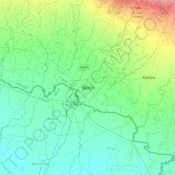
Nombre: Mapa topográfico Birgunj, altitud, relieve.
Lugar: Birgunj, Parsa, Madhesh Province, 44300, Nepal (26.85352 84.71638 27.17352 85.03638)
Altitud media: 88 m
Altitud mínima: 69 m
Altitud máxima: 152 m
Haz una donación