
Gracias por apoyar a este sitio ❤️
Haz una donación
Haz una donación
Mapa topográfico Tembagapura
Haga clic en el mapa para ver la altitud.
Gracias por apoyar a este sitio ❤️
Haz una donación
Haz una donación
Tembagapura
Tembagapura is situated on a rocky plain at an altitude of 1,930 metres (6,330 ft) at the base of Mount Zaagkam, which lies 16 kilometres (9.9 mi) southeast of the mine. The town is in the Sudirman Range, not far from Puncak Jaya (Mount Carstens), the highest peak in Oceania. The area gets about 3,220 millimetres (127 in) of rainfall each year. The weather is usually sunny in the morning, changing to cloudy and cool around noon.
Gracias por apoyar a este sitio ❤️
Haz una donación
Haz una donación
Acerca de este mapa
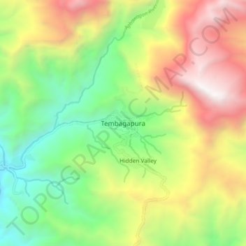
Nombre: Mapa topográfico Tembagapura, altitud, relieve.
Altitud media: 2.488 m
Altitud mínima: 1.344 m
Altitud máxima: 4.062 m
Gracias por apoyar a este sitio ❤️
Haz una donación
Haz una donación
Otros mapas topográficos
Haga clic en un mapa para ver su topografía, su altitud y su relieve.