
Haz una donación
Mapa topográfico Pilion
Haga clic en el mapa para ver la altitud.
Haz una donación
Acerca de este mapa
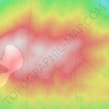
Nombre: Mapa topográfico Pilion, altitud, relieve.
Altitud media: 1.239 m
Altitud mínima: 816 m
Altitud máxima: 1.449 m
Haz una donación
Otros mapas topográficos
Haga clic en un mapa para ver su topografía, su altitud y su relieve.
Lake Karla
Greece > Thessaly and Central Greece > Regional Unit of Magnesia > Municipal Unit of Karla
After draining, site included Mavrovouni Mountain, two water reservoirs in former Lake Karla and the spring Kefalovryso in Velestino. Mavrovouni (390 km2 or 96,000 acres, max elevation 1,054 m or 3,458 ft) extends between Ossa and Pilio mountains and was restored totally in Magnesia. It mainly consists of…
Altitud media: 103 m
Municipal Unit of Karla
Greece > Thessaly and Central Greece > Regional Unit of Magnesia
Altitud media: 212 m
Volos Municipality
Greece > Thessaly and Central Greece > Regional Unit of Magnesia
Altitud media: 228 m
Haz una donación