
Haz una donación
Mapa topográfico Alamosa
Haga clic en el mapa para ver la altitud.
Haz una donación
Alamosa
Alamosa is located along the Rio Grande in the San Luis Valley, in the highest general agricultural land in the United States. Elevation is about 7,544 feet (2,299 m) in Alamosa with peaks over 14,000 feet (4,300 m) within 23 miles (37 km) of town in the Sangre de Cristo Range.
Haz una donación
Acerca de este mapa
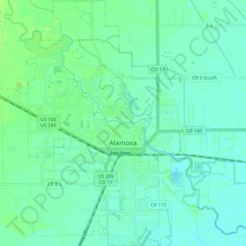
Nombre: Mapa topográfico Alamosa, altitud, relieve.
Lugar: Alamosa, Alamosa County, Colorado, 81101, United States (37.44111 -105.91372 37.50946 -105.84459)
Altitud media: 2.300 m
Altitud mínima: 2.295 m
Altitud máxima: 2.306 m
Haz una donación
Otros mapas topográficos
Haga clic en un mapa para ver su topografía, su altitud y su relieve.
Blanca Peak
United States > Colorado > Alamosa County
Blanca Peak is notable not only for its absolute height, but also for its great local relief and dominant position at the end of the range, rising high above the San Luis Valley to the west. For example, it rises nearly 7,000 feet (2,100 m) over the edge of the San Luis Valley in only 6 miles (9.7 km). Blanca…
Altitud media: 3.870 m
Haz una donación