
Gracias por apoyar a este sitio ❤️
Haz una donación
Haz una donación
Mapa topográfico Levidi
Haga clic en el mapa para ver la altitud.
Gracias por apoyar a este sitio ❤️
Haz una donación
Haz una donación
Levidi
Levidi (Greek: Λεβίδι) is a small town and a former municipality in Arcadia, Peloponnese, Greece. Since the 2011 local government reform it is part of the municipality Tripoli, of which it is a municipal unit. The municipal unit has an area of 312.641 km2. The town is situated on the northeastern slope of the Mainalo mountains, at about 850 m elevation. Levidi is 9 km northwest of Kapsas, 10 km east of Vytina, 12 km southwest of Kandila and 20 km northwest of Tripoli. It is at the junction of the Greek National Road 74 (Tripoli–Pyrgos) and the Greek National Road 66 (Levidi - Nemea).
Gracias por apoyar a este sitio ❤️
Haz una donación
Haz una donación
Acerca de este mapa
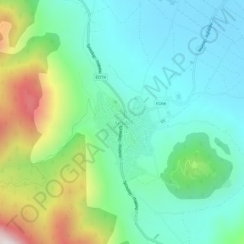
Nombre: Mapa topográfico Levidi, altitud, relieve.
Altitud media: 935 m
Altitud mínima: 668 m
Altitud máxima: 1.639 m
Gracias por apoyar a este sitio ❤️
Haz una donación
Haz una donación