
Haz una donación
Mapa topográfico Stuben
Haga clic en el mapa para ver la altitud.
Haz una donación
Stuben
Stuben am Arlberg is a winter sports resort in the town of Klösterle in the westernmost Austrian province of Vorarlberg. It is located at an altitude of 1,410 meters and had 90 inhabitants (as of 1 January 2019).
Haz una donación
Acerca de este mapa
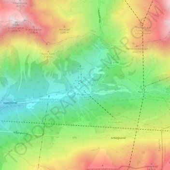
Nombre: Mapa topográfico Stuben, altitud, relieve.
Lugar: Stuben, Klösterle, Bezirk Bludenz, Vorarlberg, 6762, Austria (47.11941 10.13983 47.15941 10.17983)
Altitud media: 1.871 m
Altitud mínima: 1.279 m
Altitud máxima: 2.637 m
Haz una donación
Otros mapas topográficos
Haga clic en un mapa para ver su topografía, su altitud y su relieve.
Gemeinde Lech
Austria > Vorarlberg > Bezirk Bludenz
The altitude of 1444 m for the village refers to the location of the old church on a hill. 14.1% of the municipal area is forested, 58% of the area is Alpine. Geographically and historically, Lech belongs to the Hochtannberg region, formerly Tannberg, but in terms of tourism the municipality is part of the…
Altitud media: 1.947 m