
Haz una donación
Mapa topográfico Lianyungang
Haga clic en el mapa para ver la altitud.
Haz una donación
Lianyungang
Lianyungang City, where Huaguoshan Scenic Area is located, is located in the middle of China's thousands of miles of maritime territory, in the northeast of Jiangsu Province, bordering the Yellow Sea to the east, the Central Plains to the west, Qilu to the north, Jianghuai to the south, and facing Japan and the Korean Peninsula across the sea. The scenic area covers an area of 75.39 square kilometers and has 136 peaks. Among them, the Yunu Peak of Huaguo Mountain is the highest peak in Jiangsu Province, with an altitude of 624.4 meters and majestic cliffs.
Haz una donación
Acerca de este mapa
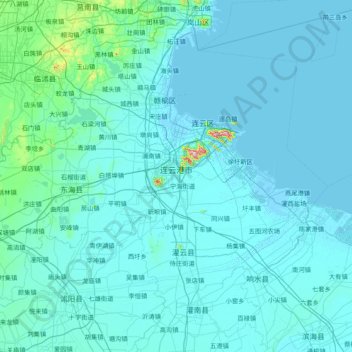
Nombre: Mapa topográfico Lianyungang, altitud, relieve.
Lugar: Lianyungang, Jiangsu, China (33.98548 118.39555 35.15528 119.94289)
Altitud media: 18 m
Altitud mínima: -3 m
Altitud máxima: 579 m
Haz una donación
Otros mapas topográficos
Haga clic en un mapa para ver su topografía, su altitud y su relieve.
Haz una donación
Haz una donación
Haz una donación