
Mapa topográfico Virginia Beach
Haga clic en el mapa para ver la altitud.
Virginia Beach
According to the United States Census Bureau, the city has a total area of 497 square miles (1,290 km2), of which 249 square miles (640 km2) is land and 248 square miles (640 km2) (49.9%) is water. It is the largest city in Virginia by total area and third-largest city land area. The average elevation is 12 feet (3.7 m) above sea level. A major portion of the city drains to the Chesapeake Bay by way of the Lynnhaven River and its tributaries.
Acerca de este mapa
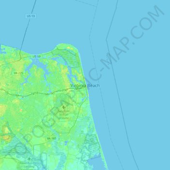
Nombre: Mapa topográfico Virginia Beach, altitud, relieve.
Lugar: Virginia Beach, Virginia, 23451, United States (36.69298 -76.13742 37.01298 -75.81742)
Altitud media: 2 m
Altitud mínima: -12 m
Altitud máxima: 17 m
Otros mapas topográficos
Haga clic en un mapa para ver su topografía, su altitud y su relieve.