
Mapa topográfico Srīnagar
Haga clic en el mapa para ver la altitud.
Acerca de este mapa
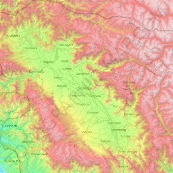
Nombre: Mapa topográfico Srīnagar, altitud, relieve.
Lugar: Srīnagar, Srinagar, Jammu and Kashmir, 190003, India (33.38333 74.13333 34.78333 75.53333)
Altitud media: 2.784 m
Altitud mínima: 709 m
Altitud máxima: 5.384 m
Otros mapas topográficos
Haga clic en un mapa para ver su topografía, su altitud y su relieve.
Anantnag district
"Sir Walter Lawrence writes in his book The Valley of Kashmir that in latitude Kashmir corresponds with Peshawar, Baghdad and Damascus in Asia: with Fez in Morocco: and South Carolina in America, but it presents none of the characteristics of those countries. People have linked the climate of Kashmir to that…
Altitud media: 2.830 m