
Gracias por apoyar a este sitio ❤️
Haz una donación
Haz una donación
Mapa topográfico Ussel
Haga clic en el mapa para ver la altitud.
Gracias por apoyar a este sitio ❤️
Haz una donación
Haz una donación
Ussel
The community of Ussel is located in the Massif central on the foothills of the plateau de Millevaches. The city itself sits on a hilltop in between the valley of the river Diège and the valley of the river Sarsonne. It is situated at an altitude of 2070 ft (631 m), in the Massif Central on the last buttress of the Plateau de Millevaches. Ussel is crossed by the Green Meridian.
Gracias por apoyar a este sitio ❤️
Haz una donación
Haz una donación
Acerca de este mapa
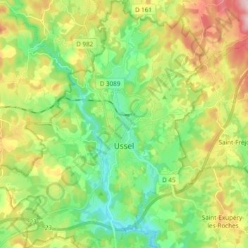
Nombre: Mapa topográfico Ussel, altitud, relieve.
Altitud media: 680 m
Altitud mínima: 582 m
Altitud máxima: 845 m
Gracias por apoyar a este sitio ❤️
Haz una donación
Haz una donación