
Gracias por apoyar a este sitio ❤️
Haz una donación
Haz una donación
Mapa topográfico Maxmo
Haga clic en el mapa para ver la altitud.
Gracias por apoyar a este sitio ❤️
Haz una donación
Haz una donación
Acerca de este mapa
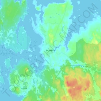
Nombre: Mapa topográfico Maxmo, altitud, relieve.
Altitud media: 9 m
Altitud mínima: -2 m
Altitud máxima: 45 m
Gracias por apoyar a este sitio ❤️
Haz una donación
Haz una donación
Otros mapas topográficos
Haga clic en un mapa para ver su topografía, su altitud y su relieve.
Gracias por apoyar a este sitio ❤️
Haz una donación
Haz una donación
Vörå
The name Vörå was first mentioned in documents in 1367 and the parish of Vörå was first mentioned in 1443. The parish name has been the subject of both historical and toponymy research since at least 1734. It has been debated whether the name is originally Swedish Vörå or Finnish Vöyri and what the…
Altitud media: 15 m
Gracias por apoyar a este sitio ❤️
Haz una donación
Haz una donación