
Haz una donación
Mapa topográfico Xiangyang
Haga clic en el mapa para ver la altitud.
Haz una donación
Acerca de este mapa
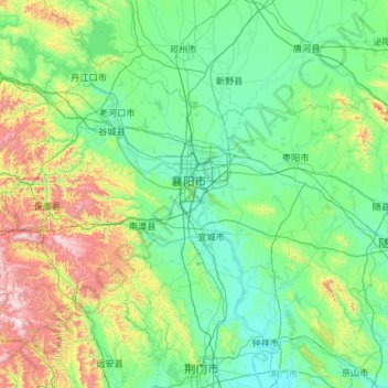
Nombre: Mapa topográfico Xiangyang, altitud, relieve.
Lugar: Xiangyang, Hubei, China (31.23051 110.75843 32.63705 113.11554)
Altitud media: 302 m
Altitud mínima: 36 m
Altitud máxima: 1.889 m
Haz una donación
Otros mapas topográficos
Haga clic en un mapa para ver su topografía, su altitud y su relieve.
Shiyan
The far northern and southern reaches of Shiyan are the highest in elevation, while the geographic center of the city has a relatively low elevation. The highest point in Shiyan is Congping in Zhuxi County, at 2,740.2 metres (8,990 ft) above sea level, while the lowest point, Panjiayan in Danjiangkou, is 87…
Altitud media: 422 m
Haz una donación
Mount Wudang
China > Hubei > Danjiangkou City
Modern maps show the elevation of the highest of the peaks in the Wudang Shan "proper" as 1612 meters; however, the entire Wudangshan range has somewhat higher elevations elsewhere.
Altitud media: 1.172 m
Mount Wudang
China > Hubei > Danjiangkou City
Modern maps show the elevation of the highest of the peaks in the Wudang Shan "proper" as 1612 meters; however, the entire Wudangshan range has somewhat higher elevations elsewhere.
Altitud media: 1.172 m
Haz una donación
Haz una donación
Haz una donación
Mount Wudang
China > Hubei > Danjiangkou City
Modern maps show the elevation of the highest of the peaks in the Wudang Shan "proper" as 1612 meters; however, the entire Wudangshan range has somewhat higher elevations elsewhere.
Altitud media: 1.172 m
Haz una donación
Yuxi
Tempered by the low latitude and moderate elevation, Yuxi has a mild subtropical highland climate (Köppen Cwb), with short, mild, dry winters, and warm, rainy summers. Frost may occur in winter but the days still generally warm up to around 17 °C (63 °F). During summer, a majority of the days features some…
Altitud media: 66 m
Haz una donación