
Haz una donación
Mapa topográfico Stanfield
Haga clic en el mapa para ver la altitud.
Haz una donación
Acerca de este mapa
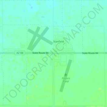
Nombre: Mapa topográfico Stanfield, altitud, relieve.
Lugar: Stanfield, Pinal County, Arizona, United States (32.86442 -111.98058 32.89397 -111.94637)
Altitud media: 396 m
Altitud mínima: 391 m
Altitud máxima: 401 m
Haz una donación
Otros mapas topográficos
Haga clic en un mapa para ver su topografía, su altitud y su relieve.
San Manuel
United States > Arizona > Pinal County
San Manuel is located at 32°36′18″N 110°38′0″W / 32.60500°N 110.63333°W / 32.60500; -110.63333 (32.605048, -110.633340), in the San Pedro River Valley at an elevation of about 3,500 feet (1,100 m). San Manuel is approximately 45 miles (72 km) northeast of Tucson.
Altitud media: 991 m
Biosphere 2 Research Center
United States > Arizona > Pinal County
The glass and spaceframe facility is located in Oracle, Arizona at the base of the Santa Catalina Mountains, about 50 minutes north of Tucson. Its elevation is around 4,000 feet (1,200 m) above sea level.
Altitud media: 1.159 m
Arizona City
United States > Arizona > Pinal County
Arizona City itself is mostly flat, lying in the Santa Cruz Valley in the center of three low mountain ranges; the Sawtooth Mountains to the south, the Picacho Mountains to the east, and the Casa Grande Mountains to the north. Picacho Peak, a prominent peak with a summit elevation of 3,374 feet (1,028 m), is…
Altitud media: 459 m
Haz una donación
Haz una donación
Apache Junction
United States > Arizona > Pinal County > Apache Junction > Apache Junction
Altitud media: 524 m
Haz una donación