
Haz una donación
Mapa topográfico Bektež
Haga clic en el mapa para ver la altitud.
Haz una donación
Acerca de este mapa
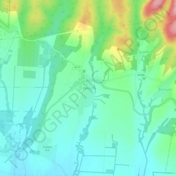
Nombre: Mapa topográfico Bektež, altitud, relieve.
Lugar: Bektež, Grad Kutjevo, Požega-Slavonia County, Croatia (45.37593 17.90600 45.41593 17.94600)
Altitud media: 194 m
Altitud mínima: 150 m
Altitud máxima: 316 m
Haz una donación
Otros mapas topográficos
Haga clic en un mapa para ver su topografía, su altitud y su relieve.
Grad Požega
Croatia > Požega-Slavonia County
Požega (elevation: 152 m (499 ft)) is located in the south-western part of the Valley of Požega, or Požega basin, in Croatian: Požeška kotlina. This fertile valley has been important since the antiquity - its Roman name was Vallis Aurea, meaning "golden valley".
Altitud media: 222 m
Haz una donación