
Haz una donación
Mapa topográfico Mae Rim
Haga clic en el mapa para ver la altitud.
Haz una donación
Acerca de este mapa
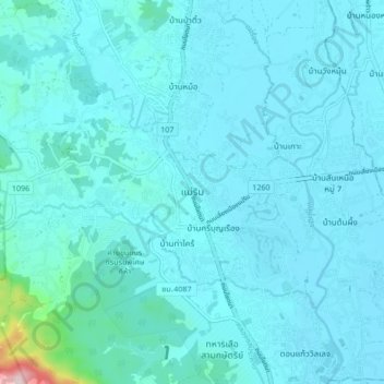
Nombre: Mapa topográfico Mae Rim, altitud, relieve.
Lugar: Mae Rim, Rim Nuea, Chiang Mai Province, 50180, Thailand (18.87446 98.90527 18.95446 98.98527)
Altitud media: 340 m
Altitud mínima: 309 m
Altitud máxima: 721 m
Haz una donación
Otros mapas topográficos
Haga clic en un mapa para ver su topografía, su altitud y su relieve.
Thailand
Thailand comprises several distinct geographic regions, partly corresponding to the provincial groups. The north of the country is the mountainous area of the Thai highlands, with the highest point being Doi Inthanon in the Thanon Thong Chai Range at 2,565 metres (8,415 ft) elevation. The northeast, Isan,…
Altitud media: 156 m
Haz una donación
Haz una donación
Surin Province
Surin lies at the center of the southern edge of the Khorat Plateau, a relatively low-lying interior region isolated from the rest of Southeast Asia by surrounding mountain ranges. The south of the province is dominated by the Dongrek mountain range, the escarpment of which demarcates the watershed boundaries…
Altitud media: 162 m
Haz una donación
Haz una donación
Ratchaburi Province
The area of Ratchaburi province is divided into three parts. First, the border in the west which is shared with Myanmar and is about 60 kilometres (37 mi) long. The second contains the Tenasserim mountains and forests with an elevation of about 200–300 meters. The central area of the province is rich in…
Altitud media: 275 m
Haz una donación
Chiang Mai Province
Chiang Mai province is about 685 km (426 mi) from Bangkok in the Mae Ping River basin and is on average at 300 m (1,000 ft) elevation. Surrounded by the mountain ranges of the Thai highlands, it covers an area of approximately 20,107 km2 (8,000 sq mi). The mountains of the Daen Lao Range…
Altitud media: 649 m
Haz una donación
Haz una donación
Tham Luang-Khun Nam Nang Non Forest Park
Thailand > Mae Sai district > Ban Pha Hi
Altitud media: 661 m
Haz una donación
Songkhla Province
The province is on the Malay Peninsula, on the coast of the Gulf of Thailand. The highest elevation is Khao Mai Kaeo at 821 meters.
Altitud media: 50 m
Haz una donación
Nakhon Nayok Province
The northern part of the province is in the Sankamphaeng Range, the southern prolongation of the Dong Phaya Yen Mountains, with the highest elevation the 1,292-meter-high Yod Khao Kiew. Most of that area is covered by the Khao Yai National Park, 2,166 km2 (836 sq mi), along with three other national parks,…
Altitud media: 183 m
Haz una donación
Bang Kruai Subdistrict
Thailand > Nonthaburi Province > Bang Kruai District > Bang Kruai Town Municipality
Altitud media: 5 m
Haz una donación
Haz una donación
Bang Chalong Subdistrict
Thailand > Samut Prakan Province > Bang Chalong Subdistrict
Altitud media: 4 m
Maha Phram Subdistrict Municipality
Thailand > Phra Nakhon Si Ayutthaya Province > Bang Ban District
Altitud media: 5 m
Haz una donación
Khu Khot Town Municipality
Thailand > Pathum Thani Province > Lam Luk Ka District > Khu Khot Town Municipality
Altitud media: 5 m
Haz una donación
Tha Khlong Town Municipality
Thailand > Pathum Thani Province > Khlong Luang District > Tha Khlong Town Municipality
Altitud media: 4 m
Khlong Chik Subdistrict
Thailand > Phra Nakhon Si Ayutthaya Province > Bang Pa-in District > Khlong Chik Subdistrict
Altitud media: 4 m
Haz una donación
Haz una donación
Mu 3
Thailand > Phra Nakhon Si Ayutthaya Province > Phra Nakhon Si Ayutthaya District > Khlong Suan Phlu Subdistrict
Altitud media: 5 m
Haz una donación
Haz una donación