
Haz una donación
Mapa topográfico Monument Valley
Haga clic en el mapa para ver la altitud.
Haz una donación
Monument Valley
The area is part of the Colorado Plateau. The elevation of the valley floor ranges from 5,000 to 6,000 feet (1,500 to 1,800 m) above sea level. The floor is largely siltstone of the Cutler Group, or sand derived from it, deposited by the meandering rivers that carved the valley. The valley's vivid red color comes from iron oxide exposed in the weathered siltstone. The darker, blue-gray rocks in the valley get their color from manganese oxide.
Haz una donación
Acerca de este mapa
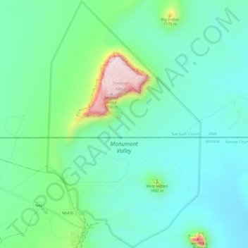
Nombre: Mapa topográfico Monument Valley, altitud, relieve.
Altitud media: 1.650 m
Altitud mínima: 1.550 m
Altitud máxima: 1.972 m
Haz una donación
Otros mapas topográficos
Haga clic en un mapa para ver su topografía, su altitud y su relieve.
Pinetop-Lakeside
United States > Arizona > Navajo County
Pinetop-Lakeside is nestled in the stunning White Mountains of northeastern Arizona, characterized by a varied topography that significantly influences its natural beauty and recreational opportunities. The terrain features elevations averaging around 6,795 feet, with rugged mountain landscapes interspersed…
Altitud media: 2.087 m
Haz una donación
Haz una donación
Haz una donación
Haz una donación
West Mitten
United States > Arizona > Navajo County
The Mittens are about 0.6 mi (0.97 km) from the Arizona–Utah state line and West Mitten Butte is 1.1 mi (1.8 km) northeast of the park headquarters. The summit of West Mitten Butte is 6,176 ft (1,882 m) and East Mitten Butte is 6,226 ft (1,898 m) in elevation. The Mittens form a triangle with Merrick Butte…
Altitud media: 1.616 m