
Gracias por apoyar a este sitio ❤️
Haz una donación
Haz una donación
Mapa topográfico Karditsa
Haga clic en el mapa para ver la altitud.
Gracias por apoyar a este sitio ❤️
Haz una donación
Haz una donación
Acerca de este mapa
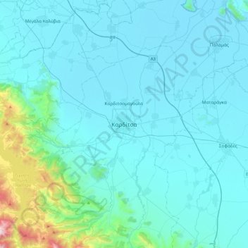
Nombre: Mapa topográfico Karditsa, altitud, relieve.
Altitud media: 231 m
Altitud mínima: 86 m
Altitud máxima: 1.656 m
Gracias por apoyar a este sitio ❤️
Haz una donación
Haz una donación
Otros mapas topográficos
Haga clic en un mapa para ver su topografía, su altitud y su relieve.
Municipal Unit of Tamasi
Greece > Thessaly and Central Greece > Karditsa Regional Unit
Altitud media: 293 m
Plastiras (Tavropos) Lake
Greece > Thessaly and Central Greece > Karditsa Regional Unit > Plastiras Municipal Unit
Today the lake holds up to 400 million cubic meters of fresh water. It is used for irrigation and as a power source of a hydroelectric plant, but also as the main water source to the city of Karditsa. Due to its altitude (one of the highest in Europe) the Tavropos Reservoir is a popular tourist resort in…
Altitud media: 792 m