
Haz una donación
Mapa topográfico El Dorado Hills
Haga clic en el mapa para ver la altitud.
Haz una donación
El Dorado Hills
El Dorado Hills (EDH), as defined by the 2010 census-designated place (CDP), is at the western border of El Dorado County, between the City of Folsom and the unincorporated community of Cameron Park. The northern limits of the CDP are Folsom Lake and the South Fork of the American River, where river rafters use Skunk Hollow and Salmon Falls as takeout landings. West of Latrobe Road, the south edge of the CDP follows railroad tracks formerly used by the Southern Pacific between the cities of Folsom and Placerville. East of Latrobe Road the south edge follows topography running roughly east–west.
Haz una donación
Acerca de este mapa
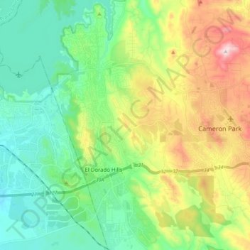
Nombre: Mapa topográfico El Dorado Hills, altitud, relieve.
Altitud media: 252 m
Altitud mínima: 80 m
Altitud máxima: 622 m
Haz una donación
Otros mapas topográficos
Haga clic en un mapa para ver su topografía, su altitud y su relieve.
El Dorado Hills
United States > California > El Dorado County > Cameron Park
El Dorado Hills (EDH), as defined by the 2020 census-designated place (CDP), is at the western border of El Dorado County, between the City of Folsom and the unincorporated community of Cameron Park. The northern limits of the CDP are Folsom Lake and the South Fork of the American River, where river rafters…
Altitud media: 250 m