
Gracias por apoyar a este sitio ❤️
Haz una donación
Haz una donación
Mapa topográfico Montecchio
Haga clic en el mapa para ver la altitud.
Gracias por apoyar a este sitio ❤️
Haz una donación
Haz una donación
Acerca de este mapa
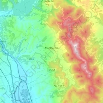
Nombre: Mapa topográfico Montecchio, altitud, relieve.
Lugar: Montecchio, Terni, Umbria, 05020, Italy (42.62200 12.23447 42.69727 12.38409)
Altitud media: 369 m
Altitud mínima: 69 m
Altitud máxima: 989 m
Gracias por apoyar a este sitio ❤️
Haz una donación
Haz una donación
Otros mapas topográficos
Haga clic en un mapa para ver su topografía, su altitud y su relieve.
Cesi
Italy > Umbria > Terni > Terni
Cesi is a frazione of the Italian comune of Terni, in the province of Terni, southern Umbria, Italy. The small borgo, which retains its late-medieval aspect, set among olive groves, lies "stretched out lengthwise along a narrow contour on the slopes of M. Torre Maggiore," about 18 km north of Terni at an…
Altitud media: 447 m
Gracias por apoyar a este sitio ❤️
Haz una donación
Haz una donación