
Mapa topográfico Bristol County
Mapa interactivo
Haga clic en el mapa para ver la altitud.
Acerca de este mapa
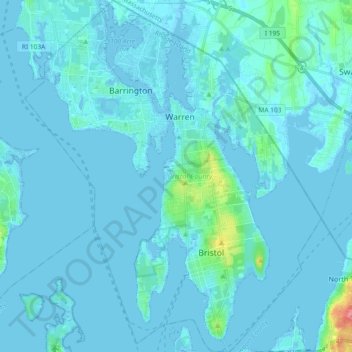
Nombre: Mapa topográfico Bristol County, altitud, relieve.
Lugar: Bristol County, Rhode Island, United States (41.63814 -71.36418 41.77614 -71.20829)
Altitud media: 6 m
Altitud mínima: -7 m
Altitud máxima: 92 m
Otros mapas topográficos
Haga clic en un mapa para ver su topografía, su altitud y su relieve.
Wickford
United States > Rhode Island > South County > North Kingstown
Wickford, North Kingstown, South County, Rhode Island, 02852, United States
Altitud media: 12 m
North Kingstown
United States > Rhode Island > South County
North Kingstown, South County, Rhode Island, United States
Altitud media: 35 m
Westerly
United States > Rhode Island > South County
Westerly, South County, Rhode Island, 02808, United States
Altitud media: 19 m
Rumford
United States > Rhode Island > Providence County
Rumford, Providence County, Rhode Island, 02916, United States
Altitud media: 12 m
Portsmouth
United States > Rhode Island > Newport County
Portsmouth, Newport County, Rhode Island, United States
Altitud media: 19 m
Providence
United States > Rhode Island > Providence County
Providence, Providence County, Rhode Island, United States
Altitud media: 19 m