
Haz una donación
Mapa topográfico Longview
Haga clic en el mapa para ver la altitud.
Haz una donación
Longview
Longview, located in Cowlitz County, Washington, is situated within a distinct topographical region. The city lies at a relatively low elevation along the Columbia River, averaging around 15 feet (5 meters) above sea level. It sits within a broad, flat valley bordered by gently rolling hills, and is impacted by the Columbia River Gorge to the north, which influences both the climate and terrain. The surrounding land features ridges and small mountainous areas, with some local elevations reaching up to 1,300 feet (396 meters). The terrain varies from flat plains near the river to higher, forested slopes, making it a unique blend of riverfront and elevated areas. The region's topography is characterized by its proximity to several rivers, including the Cowlitz River and the Columbia River, shaping the landscape and local environment.
Haz una donación
Acerca de este mapa
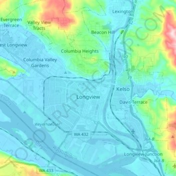
Nombre: Mapa topográfico Longview, altitud, relieve.
Lugar: Longview, Cowlitz County, Washington, 98632, United States (46.10101 -123.03939 46.18358 -122.89172)
Altitud media: 50 m
Altitud mínima: -5 m
Altitud máxima: 366 m
Haz una donación
Otros mapas topográficos
Haga clic en un mapa para ver su topografía, su altitud y su relieve.
Toutle River Sediment Retention Structure
United States > Washington > Cowlitz County
Altitud media: 347 m
Toutle River Sediment Retention Structure
United States > Washington > Cowlitz County
Altitud media: 347 m
Haz una donación