
Haz una donación
Mapa topográfico Yukon Creek
Haga clic en el mapa para ver la altitud.
Haz una donación
Acerca de este mapa
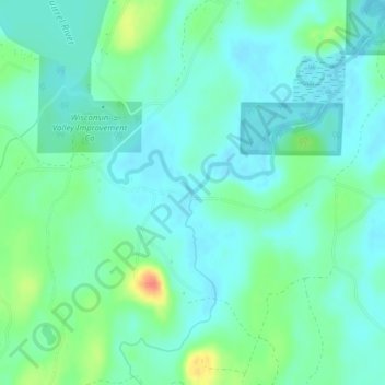
Nombre: Mapa topográfico Yukon Creek, altitud, relieve.
Altitud media: 481 m
Altitud mínima: 469 m
Altitud máxima: 516 m
Haz una donación
Otros mapas topográficos
Haga clic en un mapa para ver su topografía, su altitud y su relieve.
Rhinelander
United States > Wisconsin > Oneida County
Rhinelander has a warm-summer humid continental climate (Köppen: Dfb). Because of its location, it is prone to Arctic cold snaps, and without the western Föhn winds its winter average is lower than other places in the US at 45 °N even at high elevations. Summers tend to be cooler with some degree of Lake…
Altitud media: 482 m
Haz una donación
Haz una donación
Haz una donación
Rhinelander
United States > Wisconsin > Oneida County
Rhinelander has a warm-summer humid continental climate (Köppen: Dfb). Because of its location, it is prone to Arctic cold snaps, and without the western Föhn winds its winter average is lower than other places in the US at 45 °N even at high elevations. Summers tend to be cooler with some degree of Lake…
Altitud media: 482 m
Haz una donación