
Mapa topográfico Poages Mill
Haga clic en el mapa para ver la altitud.
Acerca de este mapa
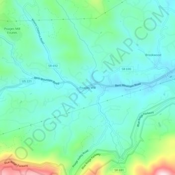
Nombre: Mapa topográfico Poages Mill, altitud, relieve.
Lugar: Poages Mill, Roanoke County, Virginia, 24018, United States (37.17819 -80.07643 37.21819 -80.03643)
Altitud media: 468 m
Altitud mínima: 370 m
Altitud máxima: 810 m
Otros mapas topográficos
Haga clic en un mapa para ver su topografía, su altitud y su relieve.
Vinton
United States > Virginia > Roanoke County
Vinton has varied topography, considering its 3.2 square mile size. The above-mentioned lake is at an elevation of 890 feet (270 m) above sea level. The Vinton side of the lake consists of a steep, wooded cliff 150 feet (46 m) in vertical height. Vinton's highest point is on Olney Road, at an elevation of…
Altitud media: 305 m