
Mapa topográfico Municipality of Nisyros
Mapa interactivo
Haga clic en el mapa para ver la altitud.
Acerca de este mapa
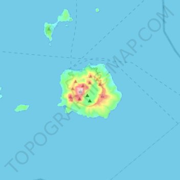
Nombre: Mapa topográfico Municipality of Nisyros, altitud, relieve.
Altitud media: 17 m
Altitud mínima: 0 m
Altitud máxima: 695 m
Otros mapas topográficos
Haga clic en un mapa para ver su topografía, su altitud y su relieve.
Zipari
Greece > Aegean > Kos Regional Unit
Zipari, Municipality of Kos, Kos Regional Unit, South Aegean, Aegean, 853 00, Greece
Altitud media: 108 m
Lambi
Greece > Aegean > Kos Regional Unit > Lambi
Lambi, Municipality of Kos, Kos Regional Unit, South Aegean, Aegean, 853000, Greece
Altitud media: 2 m
Nisyros
Greece > Aegean > Kos Regional Unit > Emborios
Nisyros, Emborios, Municipality of Nisyros, Kos Regional Unit, South Aegean, Aegean, 85303, Greece
Altitud media: 126 m