
Haz una donación
Mapa topográfico Leizhou
Haga clic en el mapa para ver la altitud.
Haz una donación
Acerca de este mapa
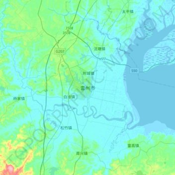
Nombre: Mapa topográfico Leizhou, altitud, relieve.
Lugar: Leizhou, Zhanjiang City, Guangdong Province, China (20.75669 109.93178 21.07669 110.25178)
Altitud media: 15 m
Altitud mínima: -3 m
Altitud máxima: 137 m
Haz una donación
Otros mapas topográficos
Haga clic en un mapa para ver su topografía, su altitud y su relieve.
Haz una donación
Nanshan District
At 587 meters (1,926 ft) tall, Yangtaishan has the highest elevation in the district, with Tanglangshan being the second at 430 meters (1,411 ft), and Nanshan, third, at 336 meters (1,102 ft). The district has a total coastline of 55.18 kilometers (34.29 mi).
Altitud media: 35 m
Haz una donación
Haz una donación
Haz una donación
Haz una donación
Jiangmen
A significant amount of historical heritage survives from the period of mass emigration prior to World War II. The most significant are the fortified multi-story towers found mainly in Kaiping. These are known as "Gold Mountain Towers" or diaolou. A number of natural hotspring resorts has been developed…
Altitud media: 31 m