
Mapa topográfico Lake Superior Provincial Park
Mapa interactivo
Haga clic en el mapa para ver la altitud.
Acerca de este mapa
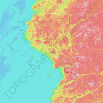
Nombre: Mapa topográfico Lake Superior Provincial Park, altitud, relieve.
Altitud media: 320 m
Altitud mínima: 176 m
Altitud máxima: 631 m
Otros mapas topográficos
Haga clic en un mapa para ver su topografía, su altitud y su relieve.
Vert Lake
Canada > Ontario > Algoma District
Vert Lake, Algoma District, Northeastern Ontario, Ontario, Canada
Altitud media: 476 m
Manitowik Lake
Canada > Ontario > Algoma District
Manitowik Lake, Algoma District, Northeastern Ontario, Ontario, Canada
Altitud media: 394 m
Cook Island
Canada > Ontario > Algoma District > The North Shore Township
Cook Island, The North Shore Township, Algoma District, Northeastern Ontario, Ontario, Canada
Altitud media: 177 m