
Haz una donación
Mapa topográfico Sierra City
Haga clic en el mapa para ver la altitud.
Haz una donación
Sierra City
Sierra City (Sierra, Spanish for "mountain range") is a census-designated place in Sierra County, California, United States. The elevation of Sierra City is 4,147 feet (1,264 m), and the town is situated in the canyon of the North Yuba River on California State Route 49, twelve miles northeast of the county seat of Sierra County, Downieville. The population was 221 at the 2010 census.
Haz una donación
Acerca de este mapa
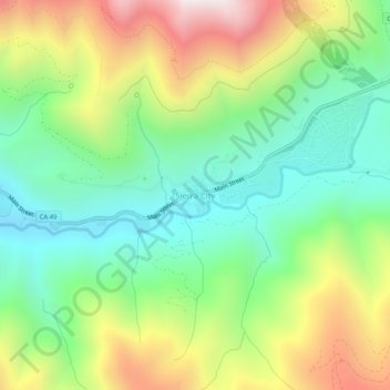
Nombre: Mapa topográfico Sierra City, altitud, relieve.
Lugar: Sierra City, Sierra County, California, United States (39.54555 -120.65600 39.58555 -120.61600)
Altitud media: 1.608 m
Altitud mínima: 1.191 m
Altitud máxima: 2.299 m
Haz una donación
Otros mapas topográficos
Haga clic en un mapa para ver su topografía, su altitud y su relieve.
Loyalton
United States > California > Sierra County
Loyalton is located at 39°40′36″N 120°14′35″W / 39.67667°N 120.24306°W / 39.67667; -120.24306 (39.676558, -120.243157). Elevation above mean sea level for the area was listed as roughly 4,930 feet (1,500 m). The city is located along California State Route 49, the Gold Country Highway.
Altitud media: 1.514 m