Geolocalizar

Mapa topográfico Lithgow

Haga clic en el mapa para ver la altitud.

Acerca de este mapa

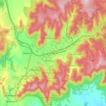
Nombre: Mapa topográfico Lithgow, altitud, relieve.

Lugar: Lithgow, New South Wales, 2790, Australia (-33.52154 150.11649 -33.44154 150.19649)

Altitud media: 986 m

Altitud mínima: 779 m

Altitud máxima: 1.176 m

Otros mapas topográficos

Haga clic en un mapa para ver su topografía, su altitud y su relieve.

Sydney

Australia > New South Wales

Sydney's topography is characterized by a diverse landscape that seamlessly blends coastal features with inland plateaus. The city is divided into two primary regions: the relatively flat Cumberland Plain to the south and west of Sydney Harbour, and the elevated Hornsby Plateau to the north. The Cumberland…

Altitud media: 53 m

Newcastle

Australia > New South Wales

Altitud media: 5 m

Eden

Australia > New South Wales

Altitud media: 55 m

Lismore

Australia > New South Wales

Altitud media: 23 m

Cooranbong

Australia > New South Wales

Altitud media: 72 m

Bowral

Australia > New South Wales

Altitud media: 690 m

Byron Bay

Australia > New South Wales

Byron Bay, located in northeastern New South Wales, Australia, is characterized by diverse topography shaped by its geological history. The town is part of the erosion caldera of the ancient Tweed Volcano, which erupted approximately 23 million years ago, resulting in the rich volcanic soils that define the…

Altitud media: 7 m

Goulburn

Australia > New South Wales

Owing to its elevation, Goulburn has an oceanic climate (Cfb) with warm summers and cool winters; with a high diurnal range. Its climate is variable much of the year, though generally dry with maximum temperatures ranging from 11.8 °C (53.2 °F) in July to 28.3 °C (82.9 °F) in January. Rainfall is…

Altitud media: 666 m

Putney

Australia > New South Wales

Altitud media: 18 m

Wagga Wagga

Australia > New South Wales

Altitud media: 183 m

Penrith

Australia > New South Wales > Sydney > Penrith

Penrith is a city in New South Wales, Australia, located in Greater Western Sydney, 55 kilometres (31 mi) west of the Sydney central business district on the banks of the Nepean River, on the outskirts of the Cumberland Plain. Its elevation is 32 metres (105 ft).

Altitud media: 34 m

Chatswood

Australia > New South Wales

Altitud media: 81 m

Blackheath

Australia > New South Wales

Blackheath (postcode: 2785) is an Australian town located near the highest point of the Blue Mountains, between Katoomba and Mount Victoria in New South Wales. The town's altitude is about 1,065 metres (3,494 ft) AHD  and it is located about 120 kilometres (75 mi) west north-west of Sydney, 11 kilometres…

Altitud media: 893 m

Umina Beach

Australia > New South Wales

Altitud media: 38 m

Tenterfield

Australia > New South Wales

Altitud media: 891 m

Perisher Valley

Australia > New South Wales

Altitud media: 1.704 m

Balgowlah

Australia > New South Wales > Sydney

Altitud media: 40 m

Bingara

Australia > New South Wales

Altitud media: 394 m

Illawarra

Australia > New South Wales

Altitud media: 234 m

Dirty Creek

Australia > New South Wales

Altitud media: 77 m

Braidwood

Australia > New South Wales

Altitud media: 674 m

Mebbin

Australia > New South Wales

Altitud media: 400 m

Portland

Australia > New South Wales

At an altitude of 925 metres above sea level, Portland is the 21st highest town in Australia and classified as a temperate zone. Cool winters and warm summers ensure four distinct seasons and snowfalls each winter.

Altitud media: 972 m

Dalgety

Australia > New South Wales

Altitud media: 866 m

Blueys Beach

Australia > New South Wales

Altitud media: 33 m

Cowan

Australia > New South Wales

Altitud media: 90 m

Barrington Tops

Australia > New South Wales

Altitud media: 1.107 m

Wauchope

Australia > New South Wales

Altitud media: 32 m

Crookwell

Australia > New South Wales

Crookwell is a small town located in the Southern Tablelands of New South Wales, Australia, in the Upper Lachlan Shire. At the 2016 census, Crookwell had a population of 2,641. The town is at a relatively high altitude of 887 metres and there are several snowfalls during the winter months. The nearest major…

Altitud media: 904 m

Sydney

Australia > New South Wales > Sydney

Altitud media: 23 m

Box Hill

Australia > New South Wales > Sydney

Altitud media: 45 m

Blue Mountains

Australia > New South Wales

A sandstone plateau dominated by a landscape of endless eucalyptus forests, the Blue Mountains are located at the top of a 470-million-year-old quartzite. In the Permian period, a shallow sea covered the region, when rivers brought shales, siltstones and mudstones. Then during the Mesozoic period, rivers…

Altitud media: 566 m

Mount Victoria

Australia > New South Wales

Mount Victoria (postcode: 2786) is a small township in the Blue Mountains of New South Wales, Australia. Mount Victoria is geographically the western most village and suburb of Greater Sydney on the great western highway in the City of Blue Mountains, located about 120 kilometres (75 mi) west-northwest by road…

Altitud media: 901 m

Wingham

Australia > New South Wales

Altitud media: 47 m

St Leonards

Australia > New South Wales > Sydney

Altitud media: 69 m

Snowball

Australia > New South Wales

Altitud media: 1.001 m

Parramatta

Australia > New South Wales

Altitud media: 22 m

Campbelltown

Australia > New South Wales

Altitud media: 96 m

Tahmoor

Australia > New South Wales

Altitud media: 269 m

Greystanes

Australia > New South Wales > Sydney

Altitud media: 53 m

Katoomba

Australia > New South Wales

Altitud media: 904 m

Terrigal

Australia > New South Wales

Altitud media: 13 m

Glen Innes

Australia > New South Wales

Altitud media: 1.083 m

Manly Vale

Australia > New South Wales > Sydney

Altitud media: 34 m

Kulnura

Australia > New South Wales

Altitud media: 203 m

Dee Why

Australia > New South Wales > Sydney

Altitud media: 31 m

Molong

Australia > New South Wales

Altitud media: 595 m

Glenhaven

Australia > New South Wales > Sydney

Altitud media: 132 m

Gables

Australia > New South Wales > Sydney

Altitud media: 47 m

Inner West

Australia > New South Wales > Sydney

Altitud media: 19 m

Nerrigundah

Australia > New South Wales

Altitud media: 189 m

Mudgee

Australia > New South Wales

Altitud media: 535 m

Leppington

Australia > New South Wales

Altitud media: 89 m

Emmaville

Australia > New South Wales

Emmaville is at an elevation of 890 metres AHD. At the 2006 census, the Emmaville "urban centre/locality" had a population of 247 (in the 2001 census it was 303) and there were 535 persons usually resident in the Emmaville region.

Altitud media: 859 m

East Gosford

Australia > New South Wales

Altitud media: 25 m

Glenwood

Australia > New South Wales

Altitud media: 69 m

Hazelbrook

Australia > New South Wales

Hazelbrook is a town in New South Wales, Australia (Elevation: 675 metres) It is located 91 kilometres west of Sydney and 16 kilometres east of Katoomba in the Blue Mountains on the Great Western Highway.

Altitud media: 610 m

Bilgola Plateau

Australia > New South Wales

The suburb is mainly residential, with two small rows of shops, a small park and a primary school located on the top of the plateau. Bilgola Beach on the eastern side features a surf club and kiosk. Rising to an elevation of 150m above sea level, the suburb has views of the beach and the ocean on the eastern…

Altitud media: 37 m

Kingscliff

Australia > New South Wales

Altitud media: 5 m

Nepean River

Australia > New South Wales

Altitud media: 601 m

Orange

Australia > New South Wales

Orange is a city in the Central Tablelands region of New South Wales, Australia. It is 254 km (158 mi) west of the state capital, Sydney [206 km (128 mi) on a great circle], at an altitude of 862 metres (2,828 ft). Orange had an estimated urban population of 40,493 as of June 2018 making the city a significant…

Altitud media: 852 m

Cromer

Australia > New South Wales

Altitud media: 46 m

East Lismore

Australia > New South Wales

Altitud media: 41 m

Gwydir River

Australia > New South Wales

Over its entire distance, the Gwydir River falls around 616 metres (2,021 ft) in elevation from its headwaters, at an elevation of 760 metres (2,490 ft) above sea level to when it joins the Barwon River at an elevation of 144 metres (472 ft) above sea level. The Gwydir River's total length is 488 kilometres…

Altitud media: 541 m

Grose Valley

Australia > New South Wales > Blackheath

The bulk of the vegetation in the wilderness is dry open forest and woodland, dominated by Eucalyptus sieberi and E. piperita above 800 metres (2,600 ft) altitude with Eucalyptus oblonga, E. globoidea, E. agglomerata and Angophora costata becoming dominant at lower altitudes. Plateau areas have thinner or…

Altitud media: 833 m

Ellalong

Australia > New South Wales

Altitud media: 162 m

Bribbaree

Australia > New South Wales

Altitud media: 264 m

Bulahdelah

Australia > New South Wales

Altitud media: 104 m

Perthville

Australia > New South Wales

Altitud media: 733 m

Colo Heights

Australia > New South Wales

Altitud media: 278 m

Alison

Australia > New South Wales

Altitud media: 93 m

Congarinni

Australia > New South Wales

Altitud media: 34 m

Old Grevillia

Australia > New South Wales

Altitud media: 189 m