
Haz una donación
Mapa topográfico Thiruvalla
Haga clic en el mapa para ver la altitud.
Haz una donación
Thiruvalla
Thiruvalla lies at an altitude of 9 meters above sea level on the basin of the Pamba and Manimala rivers. Thiruvalla is dotted with several natural canal streams (called "thodu" in Malayalam) like Chanthathodu, Manippuzha, Mullelithodu, and several others. The city area has riverine alluvial soil, and eastern parts have a laterite loam kind of soil classified under "Southern Midlands" agro-ecological zone, while the western suburbs like Niranam have a more sandy type of soil that resembles beaches. (Kuttanad agro-ecological zone)[7] The reason for this is believed to be the older status of Niranam as a port, before reclamation of Kuttanad from sea occurred. The Upper Kuttanad region in Thiruvalla has the "Karappadam" type of soil, which is clay loam in texture, has high organic matter, and is situated in areas about 1–2 m above sea level.[7]
Haz una donación
Acerca de este mapa
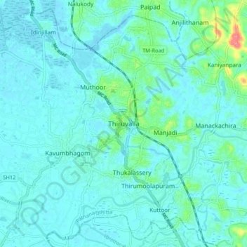
Nombre: Mapa topográfico Thiruvalla, altitud, relieve.
Lugar: Thiruvalla, Pathanamthitta, Kerala, 689111, India (9.34674 76.53627 9.42674 76.61627)
Altitud media: 10 m
Altitud mínima: -1 m
Altitud máxima: 74 m
Haz una donación
Otros mapas topográficos
Haga clic en un mapa para ver su topografía, su altitud y su relieve.