
Mapa topográfico Horsley
Haga clic en el mapa para ver la altitud.
Acerca de este mapa
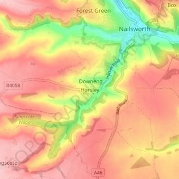
Nombre: Mapa topográfico Horsley, altitud, relieve.
Altitud media: 160 m
Altitud mínima: 56 m
Altitud máxima: 220 m
Otros mapas topográficos
Haga clic en un mapa para ver su topografía, su altitud y su relieve.
Jubilee Playing Field & Athletics Track
United Kingdom > England > Gloucestershire > Stroud > Cam > Draycott
Altitud media: 45 m
Rodborough Common
United Kingdom > England > Gloucestershire > Stroud > Lightpill
Altitud media: 114 m
Gloucester and Sharpness Canal
United Kingdom > England > Gloucestershire > Stroud
Altitud media: 34 m
River Frome
United Kingdom > England > Gloucestershire > Stroud > Chalford > Chalford Hill
Altitud media: 163 m
Alderley
United Kingdom > England > Gloucestershire > Stroud
In A Topographical Dictionary of England by Samuel Lewis published in 1831, Alderley is described thus.
Altitud media: 95 m