
Gracias por apoyar a este sitio ❤️
Haz una donación
Haz una donación
Mapa topográfico Aborlan
Haga clic en el mapa para ver la altitud.
Gracias por apoyar a este sitio ❤️
Haz una donación
Haz una donación
Acerca de este mapa
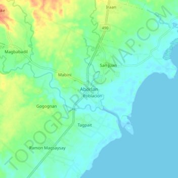
Nombre: Mapa topográfico Aborlan, altitud, relieve.
Lugar: Aborlan, Palawan, Mimaropa, 5302, Philippines (9.39710 118.50842 9.47710 118.58842)
Altitud media: 13 m
Altitud mínima: -3 m
Altitud máxima: 52 m
Gracias por apoyar a este sitio ❤️
Haz una donación
Haz una donación
Otros mapas topográficos
Haga clic en un mapa para ver su topografía, su altitud y su relieve.
Cuyo
Cuyo Island is the largest island of the Cuyo Archipelago, about 13 kilometres (8.1 mi) long, 7.5 kilometres (4.7 mi) wide, and with an area of 57 square kilometres (22 sq mi). Mount Bonbon with an elevation of 817 ft (249 m) is the highest mountain in Cuyo island. The Island is under the jurisdiction of the…
Altitud media: 0 m