Mapa topográfico Qingdao
Haga clic en el mapa para ver la altitud.
Qingdao
Qingdao is located on the south-facing coast of the Shandong Peninsula (German: Schantung-Halbinsel). It borders three prefecture-level cities, namely Yantai to the northeast, Weifang to the west, and Rizhao to the southwest. The city occupies an area totaling 10,654 km2 (4,114 sq mi), and stretches in latitude from 35° 35' to 37° 09' N and in longitude from 119° 30' to 121° 00' E. The populated sections of the city are relatively flat while mountains spur up within city limits and nearby. The highest elevation in the city is located 1,133 meters (3,717 ft) above sea level. Of the total area of Qingdao, 15.5% is highland, while the foothill, plain, and lowland areas constitute 25.1%, 37.8%, and 21.7%, respectively. The city has a 730.64-kilometer (454.00 mi)-long coastline. Five significant rivers exceeding 50 kilometers (31 mi) in length can be found in the region.
Acerca de este mapa
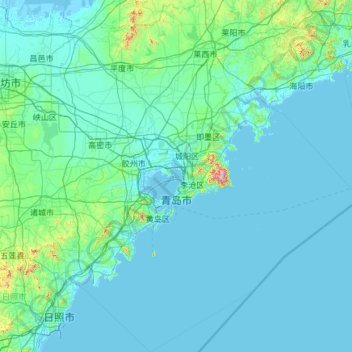
Nombre: Mapa topográfico Qingdao, altitud, relieve.
Lugar: Qingdao, Shandong, 266000, China (35.45172 119.50922 37.14847 121.56990)
Altitud media: 41 m
Altitud mínima: -2 m
Altitud máxima: 1.011 m
Otros mapas topográficos
Haga clic en un mapa para ver su topografía, su altitud y su relieve.


Qingdao
Qingdao is located on the south facing coast of the Shandong Peninsula (German: Schantung Halbinsel). It borders three prefecture-level cities, namely Yantai to the northeast, Weifang to the west, and Rizhao to the southwest. The city's total jurisdiction area occupies 10,654 square kilometres (4,114 sq mi),…
Altitud media: 25 m