
Haz una donación
Mapa topográfico Sacheen Lake
Haga clic en el mapa para ver la altitud.
Haz una donación
Acerca de este mapa
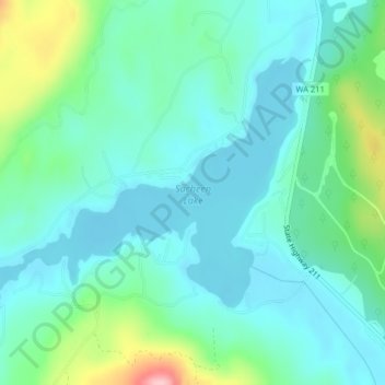
Nombre: Mapa topográfico Sacheen Lake, altitud, relieve.
Altitud media: 715 m
Altitud mínima: 678 m
Altitud máxima: 846 m
Haz una donación
Otros mapas topográficos
Haga clic en un mapa para ver su topografía, su altitud y su relieve.
Newport
United States > Washington > Pend Oreille County
Newport is located at an elevation of 2,160 feet (658.5 m) and according to the United States Census Bureau, the city has a total area of 1.07 square miles (2.77 km2), all of it land.
Altitud media: 662 m
Ione
United States > Washington > Pend Oreille County
Ione is situated on the west bank of the Pend Oreille River as it flows north towards Canada. Big Muddy Creek, Little Muddy Creek and Cedar Creek, from south to north, join the river in Ione. State Route 31 passes through town. Ione Bridge, on the southern edge of town, is the only road crossing of the Pend…
Altitud media: 670 m
Kalispel Reservation
United States > Washington > Pend Oreille County > Airway Heights
Altitud media: 801 m
Haz una donación
Ione
United States > Washington > Pend Oreille County
Ione is situated on the west bank of the Pend Oreille River as it flows north towards Canada. Big Muddy Creek, Little Muddy Creek and Cedar Creek, from south to north, join the river in Ione. State Route 31 passes through town. Ione Bridge, on the southern edge of town, is the only road crossing of the Pend…
Altitud media: 670 m
Newport
United States > Washington > Pend Oreille County
Newport is located at an elevation of 2,160 feet (658.5 m) and according to the United States Census Bureau, the city has a total area of 1.07 square miles (2.77 km2), all of it land.
Altitud media: 662 m
Haz una donación