
Gracias por apoyar a este sitio ❤️
Haz una donación
Haz una donación
Mapa topográfico Coyote Gulch
Haga clic en el mapa para ver la altitud.
Gracias por apoyar a este sitio ❤️
Haz una donación
Haz una donación
Acerca de este mapa
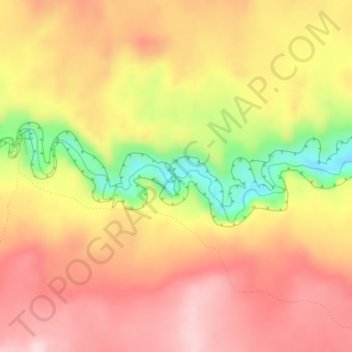
Nombre: Mapa topográfico Coyote Gulch, altitud, relieve.
Lugar: Coyote Gulch, Kane County, Utah, United States (37.41642 -111.02782 37.41644 -111.02751)
Altitud media: 1.361 m
Altitud mínima: 1.198 m
Altitud máxima: 1.460 m
Gracias por apoyar a este sitio ❤️
Haz una donación
Haz una donación
Otros mapas topográficos
Haga clic en un mapa para ver su topografía, su altitud y su relieve.