
Haz una donación
Mapa topográfico Lake San Cristobal
Haga clic en el mapa para ver la altitud.
Haz una donación
Lake San Cristobal
Lake San Cristobal is a lake in the U.S. state of Colorado. Located in the San Juan Mountains at an elevation of 9,003 feet (2,744 m), the freshwater lake is 2.1 miles (3.4 km) long, up to 89 feet (27 m) deep, has a surface area of 0.52 square miles (1.3 km2), and holds about 11,000 acre-feet (14,000,000 m3) of water. The town of Lake City, a few miles to the north, is named after Lake San Cristobal. The name San Cristóbal means Saint Christopher in the Spanish language. Many old silver mines are near the lake and it is very clean and well kept, and stocked with Rainbow Trout.
Haz una donación
Acerca de este mapa
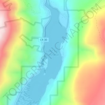
Nombre: Mapa topográfico Lake San Cristobal, altitud, relieve.
Altitud media: 2.947 m
Altitud mínima: 2.744 m
Altitud máxima: 3.326 m
Haz una donación
Otros mapas topográficos
Haga clic en un mapa para ver su topografía, su altitud y su relieve.