
Mapa topográfico Municipality of Galatsi
Mapa interactivo
Haga clic en el mapa para ver la altitud.
Acerca de este mapa
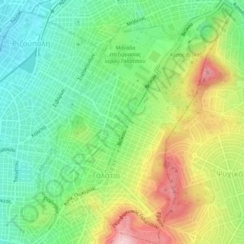
Nombre: Mapa topográfico Municipality of Galatsi, altitud, relieve.
Altitud media: 176 m
Altitud mínima: 87 m
Altitud máxima: 317 m
Otros mapas topográficos
Haga clic en un mapa para ver su topografía, su altitud y su relieve.
Athens
Greece > Attica > Regional Unit of Central Athens
Athens, Municipality of Athens, Regional Unit of Central Athens, Attica, 105 57, Greece
Altitud media: 168 m
Municipality of Zografos
Greece > Attica > Regional Unit of Central Athens
Municipality of Zografos, Regional Unit of Central Athens, Attica, Greece
Altitud media: 333 m
Municipality of Dafni - Ymittos
Greece > Attica > Regional Unit of Central Athens
Municipality of Dafni - Ymittos, Regional Unit of Central Athens, Attica, Greece
Altitud media: 128 m
Areopagus
Greece > Attica > Regional Unit of Central Athens > Athens
Areopagus, Athens, Municipality of Athens, Regional Unit of Central Athens, Attica, 105 55, Greece
Altitud media: 75 m