
Gracias por apoyar a este sitio ❤️
Haz una donación
Haz una donación
Mapa topográfico Malangas
Haga clic en el mapa para ver la altitud.
Gracias por apoyar a este sitio ❤️
Haz una donación
Haz una donación
Malangas
Malangas also includes the island of Muyong, having endowed with white sand beaches, and other of uninhabited islands near the shorelines. Mainland area are steeply sloping terrain of hills and mountains. Due to its topography and elevation the town do not experience flooding.
Gracias por apoyar a este sitio ❤️
Haz una donación
Haz una donación
Acerca de este mapa
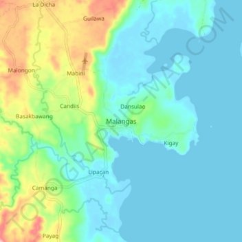
Nombre: Mapa topográfico Malangas, altitud, relieve.
Altitud media: 38 m
Altitud mínima: -4 m
Altitud máxima: 172 m
Gracias por apoyar a este sitio ❤️
Haz una donación
Haz una donación
Otros mapas topográficos
Haga clic en un mapa para ver su topografía, su altitud y su relieve.