
Mapa topográfico Mankial
Haga clic en el mapa para ver la altitud.
Acerca de este mapa
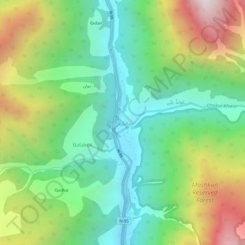
Nombre: Mapa topográfico Mankial, altitud, relieve.
Altitud media: 2.210 m
Altitud mínima: 1.613 m
Altitud máxima: 3.298 m
Otros mapas topográficos
Haga clic en un mapa para ver su topografía, su altitud y su relieve.
Kalam Tehsil
Pakistan > Khyber Pakhtunkhwa > Swat District
At an elevation about 2,000 m (6,600 ft) above sea level, the valley itself provides a plateau that is located above the river and is used for farming. There are a number of visible mountains, also visible from Matiltan, a valley close to Kalam Valley, including Mount Falaksar at 5,918 meters (19,416 feet),…
Altitud media: 3.920 m