
Haz una donación
Mapa topográfico Anyang
Haga clic en el mapa para ver la altitud.
Haz una donación
Anyang
Anyang spans a total area of 7,355 square kilometres (2,840 sq mi). The city's elevation is generally higher in the west, with the foothills of the Taihang Mountains running through the area, and lower in the east, which comprises part of the North China Plain.
Haz una donación
Acerca de este mapa
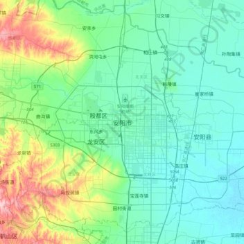
Nombre: Mapa topográfico Anyang, altitud, relieve.
Lugar: Anyang, Beiguan District, Anyang City, Henan, China (35.94236 114.17633 36.26236 114.49633)
Altitud media: 102 m
Altitud mínima: 56 m
Altitud máxima: 275 m
Haz una donación
Otros mapas topográficos
Haga clic en un mapa para ver su topografía, su altitud y su relieve.
Haz una donación
Shangqiu City
Shangqiu is the easternmost prefecture of Henan province. Its administrative area ranges in longitude from 114 °49′ E to 116° 39′ E and in latitude from 33° 43′ N to 34° 52′ N, covering 10,704 square kilometres (4,133 sq mi). The city lies on the North China Plain and is mostly flat, with…
Altitud media: 47 m
Haz una donación
Haz una donación