
Haz una donación
Mapa topográfico Guanyin
Haga clic en el mapa para ver la altitud.
Haz una donación
Acerca de este mapa
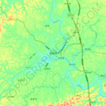
Nombre: Mapa topográfico Guanyin, altitud, relieve.
Lugar: Guanyin, Xuzhou District, Yibin, Sichuan, 644604, China (29.05654 104.35454 29.13654 104.43454)
Altitud media: 330 m
Altitud mínima: 298 m
Altitud máxima: 385 m
Haz una donación
Otros mapas topográficos
Haga clic en un mapa para ver su topografía, su altitud y su relieve.
Hongyuan County
This is the only county under the Prefecture with entirely yak herding pastoralists. The average altitude above the sea level is 3,600 m (11,800 ft). About 8,398 square meter and about 40,000 people reside (2004) mostly Amdo Tibetan. The language is spoken is one of the most conservative dialect among the Amdo…
Altitud media: 3.706 m
Songpan County
Due to its altitude, Songpan has a humid continental climate (Köppen Dwb), with cool winters and warm, rainy summers. The monthly 24-hour average temperature ranges from −3.4 °C (25.9 °F) in January to 14.8 °C (58.6 °F) in July, and the annual mean is 6.28 °C (43.3 °F). The high elevation also results…
Altitud media: 3.301 m
Garzê County
Due to its elevation, Garzê County has a monsoon-influenced humid continental climate (Köppen Dwb) and subarctic climate, with cold but very dry winters, and warm summers with frequent rain. The monthly 24-hour average temperature ranges from −3.9 °C (25.0 °F) in January to 14.2 °C (57.6 °F) in July,…
Altitud media: 4.281 m
Huanglong Scenic and Historic Interest Area
China > Sichuan > Songpan County
Repeated glaciation events, the unique terrane structure, the formation of tufa, the stratum of carbonic acid rock, and climatic conditions such as Arctic-alpine sunlight have created this world-famous travertine landscape. Huanglong covers an area of 700 km2 at an altitude between 1700m and 5588m. Major…
Altitud media: 3.350 m
Haz una donación
Haz una donación
Muli Tibetan Autonomous County
Since 1987, Muli Monastery has been partly restored and now has about eighty young monks in residence. It is near a modern small town called Wachang, located high up on the western edge of the Litang River Valley at about 3000 metres altitude. The other monasteries are Kulu (now known as Kangwu), which has…
Altitud media: 3.390 m
Haz una donación