
Haz una donación
Mapa topográfico Orane/Orani
Haga clic en el mapa para ver la altitud.
Haz una donación
Orane/Orani
Orani sits at an altitude of 526 meters, at the foot of Mount Gonare, in the heart of the Barbagia region. Among the notable archaeological sites in the area are approximately 30 nuraghi and several “tombs of the giants”. The Sanctuary of Our Lady of Gonare at the crest of the mountain is of particular interest, as is the natural landscape on the road leading up to it. Orani excels in handicrafts. It is famous for its stonework, carpentry, and metalwork, and for tailors specializing in the use of traditional Sardinian velvet. The city is also home to the Nivola Museum.
Haz una donación
Acerca de este mapa
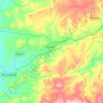
Nombre: Mapa topográfico Orane/Orani, altitud, relieve.
Lugar: Orane/Orani, Nuoro, Sardinia, 08026, Italy (40.21202 9.02626 40.37283 9.27901)
Altitud media: 505 m
Altitud mínima: 186 m
Altitud máxima: 1.072 m
Haz una donación
Otros mapas topográficos
Haga clic en un mapa para ver su topografía, su altitud y su relieve.