
Haz una donación
Mapa topográfico Port Angeles
Haga clic en el mapa para ver la altitud.
Haz una donación
Port Angeles
Port Angeles is characterized by a diverse and dramatic topography that reflects its unique geographic position on the Olympic Peninsula. Situated at approximately 72 feet above sea level, the city rises from the shores of the Strait of Juan de Fuca and is bordered by the Olympic Mountains to the south, which soar to elevations exceeding 7,000 feet. This mountainous backdrop is notable for its steep slopes and deep valleys, shaped by glacial activity and erosion. The surrounding landscape features a mixture of rugged terrain and lush forests, with numerous rivers and streams that traverse the area, enhancing its scenic beauty and providing habitats for local wildlife. Additionally, the coastline is marked by rocky shorelines and sandy beaches, creating a rich environment for both recreation and biodiversity.
Haz una donación
Acerca de este mapa
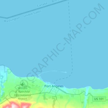
Nombre: Mapa topográfico Port Angeles, altitud, relieve.
Altitud media: 27 m
Altitud mínima: -6 m
Altitud máxima: 501 m
Haz una donación
Otros mapas topográficos
Haga clic en un mapa para ver su topografía, su altitud y su relieve.
Haz una donación
Haz una donación
Haz una donación