
Haz una donación
Mapa topográfico Culleoka
Haga clic en el mapa para ver la altitud.
Haz una donación
Acerca de este mapa
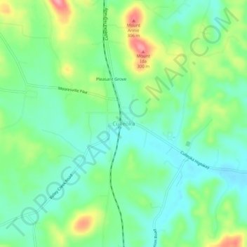
Nombre: Mapa topográfico Culleoka, altitud, relieve.
Altitud media: 233 m
Altitud mínima: 197 m
Altitud máxima: 306 m
Haz una donación
Otros mapas topográficos
Haga clic en un mapa para ver su topografía, su altitud y su relieve.
Columbia
United States > Tennessee > Maury County
According to the United States Census Bureau, the city has a total area of 29.6 square miles (77 km2), of which 29.6 square miles (77 km2) is land and 0.03% is water. Incorporated in 1817, the city is at an elevation of 637 feet (194 m).
Altitud media: 214 m
Haz una donación