
Gracias por apoyar a este sitio ❤️
Haz una donación
Haz una donación
Mapa topográfico Donut Falls
Haga clic en el mapa para ver la altitud.
Gracias por apoyar a este sitio ❤️
Haz una donación
Haz una donación
Acerca de este mapa
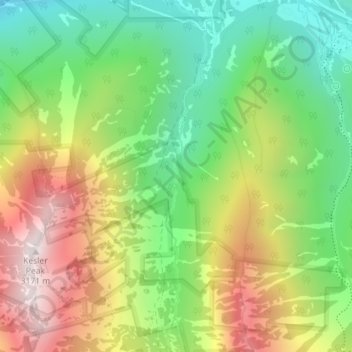
Nombre: Mapa topográfico Donut Falls, altitud, relieve.
Lugar: Donut Falls, Salt Lake County, Utah, 84138, United States (40.63087 -111.65456 40.63097 -111.65446)
Altitud media: 2.581 m
Altitud mínima: 2.161 m
Altitud máxima: 3.147 m
Gracias por apoyar a este sitio ❤️
Haz una donación
Haz una donación
Otros mapas topográficos
Haga clic en un mapa para ver su topografía, su altitud y su relieve.
Kearns
United States > Utah > Salt Lake County
Kearns, in the mid to late twentieth century, saw rapid growth on the former airbase. The old streets and foundations of buildings built by the military were used as a template for the town, and homes sprang up quickly as Kearns was becoming the first suburb in Salt Lake County. By the 1970s and into the…
Altitud media: 1.408 m
Gracias por apoyar a este sitio ❤️
Haz una donación
Haz una donación