
Haz una donación
Mapa topográfico Langowan
Haga clic en el mapa para ver la altitud.
Haz una donación
Acerca de este mapa
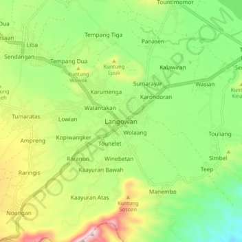
Nombre: Mapa topográfico Langowan, altitud, relieve.
Lugar: Langowan, Minahasa, North Sulawesi, Sulawesi, Indonesia (1.11485 124.80028 1.19485 124.88028)
Altitud media: 740 m
Altitud mínima: 483 m
Altitud máxima: 1.157 m
Haz una donación
Otros mapas topográficos
Haga clic en un mapa para ver su topografía, su altitud y su relieve.
Haz una donación
Tomohon
Tomohon has a cooler temperature than Manado (Tomohon's neighbor city) which is at a lower land nearby the sea. Tomohon is situated at an altitude of about 700–1,000 metres (2,300–3,300 ft) above sea level (asl), Temperatures in Tomohon in the daytime are between 17–30 °C (63–86 °F) and 16–24 °C…
Altitud media: 715 m
Kepulauan Sangihe
Topography of the islands mostly consists of hills and steep topography for bigger islands such as Sangihe and Siau. Around 55.4% of land area in the regency has slope above 40%. Soil composition consist of alluvium, which mostly used for residential areas. Elevation varies from 0 to 1,800 metres above sea…
Altitud media: 2 m
Haz una donación
Haz una donación
Kepulauan Sangihe
Topography of the islands mostly consists of hills and steep topography for bigger islands such as Sangihe and Siau. Around 55.4% of land area in the regency has slope above 40%. Soil composition consist of alluvium, which mostly used for residential areas. Elevation varies from 0 to 1,800 metres above sea…
Altitud media: 2 m
Haz una donación