
Haz una donación
Mapa topográfico Champagne
Haga clic en el mapa para ver la altitud.
Haz una donación
Acerca de este mapa
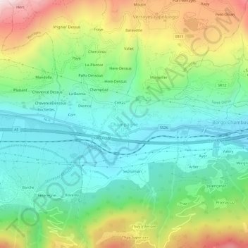
Nombre: Mapa topográfico Champagne, altitud, relieve.
Lugar: Champagne, Verrayes, Aosta Valley, Italy (45.72417 7.50498 45.76417 7.54498)
Altitud media: 740 m
Altitud mínima: 466 m
Altitud máxima: 1.298 m
Haz una donación
Otros mapas topográficos
Haga clic en un mapa para ver su topografía, su altitud y su relieve.
Haz una donación
Courmayeur
At an elevation of 1,224 m (4,016 ft) above sea level, it is located at the foot of the southern side of Mont Blanc, at 4,810 m (15,781 ft) the highest point in the Alps and western Europe (see Seven Summits), and is crossed by the Dora Baltea (fr. Doire baltée) river.
Altitud media: 2.366 m
Haz una donación
Haz una donación
Gran Paradiso National Park
Italy > Aosta Valley > Torino
The park is located in the Graian Alps in the regions of Piedmont (in the Metropolitan City of Turin) and Aosta Valley in northwest Italy. It encompasses 703 square kilometres (174,000 acres) of alpine terrain. 10% of the park's surface area is wooded. 16.5% is used for agriculture and pasture, 24% is…
Altitud media: 2.135 m
Haz una donación
Gran Paradiso National Park
Italy > Aosta Valley > Turin
The park is located in the Graian Alps in the regions of Piedmont (in the Metropolitan City of Turin) and Aosta Valley in northwest Italy. It encompasses 703 square kilometres (174,000 acres) of alpine terrain. 10% of the park's surface area is wooded. 16.5% is used for agriculture and pasture, 24% is…
Altitud media: 2.135 m
Haz una donación
Haz una donación
Haz una donación
Courmayeur
At an elevation of 1,224 m (4,016 ft) above sea level, it is located at the foot of the southern side of Mont Blanc, at 4,810 m (15,781 ft) the highest point in the Alps and western Europe (see Seven Summits), and is crossed by the Dora Baltea (fr. Doire baltée) river.
Altitud media: 2.366 m
Haz una donación
Courmayeur
At an elevation of 1,224 m (4,016 ft) above sea level, it is located at the foot of the southern side of Mont Blanc, at 4,810 m (15,781 ft) the highest point in the Alps and western Europe (see Seven Summits), and is crossed by the Dora Baltea (fr. Doire baltée) river.
Altitud media: 2.366 m
Haz una donación
Haz una donación
Haz una donación